 _______________________________
 __________________________________
 “In towns and cities... there is no more important institution than the local paper.”
Warren Buffett
By Pete Parker and Randy Economy
A statewide census map has been released by the California Environmental Protection Agency (CEAP) to expose the area’s most laden by pollution, which provides pressure to members of the community with long-term health risks.
The finding show that many local communities in and around Southeast Los Angeles County have scored poorly in regards to the condition of their air quality.
One city in particular has scored low in the survey with the western part of Cerritos being designated by state officials as being at high-risk levels for contaminants.
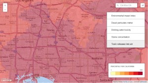
The visual provided by the CEAP shows the Environmental impact index, Diesel particulate matter, Drinking water toxicity, Ozone concentration and Toxic releases into air.
Los Angeles County, San Joaquin Valley and the Inland Empire suffer from the most pollutants in the California and local cities in the “Gateway Region” appear to be no better.
The cities of Downey, Bell Gardens, Montebello, Cerritos, Artesia, Hawaiian Gardens, Norwalk, La Habra, La Palma, La Mirada Lakewood, Bellflower and Commerce are centered within the contaminants polluting our environment. Many residents in these areas include working class to low-income Latino families who have had little influence or lack authority on the improvements of their communities.
Environmental activists are saying that this new tool, released by Cal/EPA, provides the public with an approximate realistic view of conditions in areas as small as a few thousand residents which pressures officials to act in highly polluted neighborhoods.
In 2009, a major controversy erupted when USA Today published an emotionally charged series of articles that claimed Cerritos had one of the most “dangerous” air qualities in the United States.
The AQMD also tested emissions from a chemical treatment facility the EPA report blamed for much of the risk in Cerritos at the corner of Carmenita Road and Alondra Boulevard and found its current pollution levels were far lower than those the EPA cited.
The EPA sent a letter July 16 of 2009 to then Cerritos Mayor Bruce Barrows saying emissions from the facility “are now known to be at a safe level.” The letter said the EPA would investigate further and promised “to continue to improve the accuracy” of the information, it releases.
Barrows and officials from Cerritos spent hundreds of thousands of public tax dollars in media consultants to fight the negative publicity that was generated by that past article published by USA Today. The previous situation was covered by media outlets as far away as London, China and South America.
USA Today eventually reported that local municipal officials challenged the U.S. Environmental Protection Agency “identified a neighborhood in Cerritos as facing the nation’s highest cancer risk from air emissions. After the EPA released its assessment, which USA TODAY reported on June 24, California’s South Coast Air Quality Management District reviewed the data and found gross overestimation in Cerritos and several other places because the EPA relied on outdated or incorrect emission data.”
The USA Today also reported, “The AQMD also tested emissions from a facility the EPA report blamed for much of the risk in Cerritos and found its current pollution levels were far lower than those the EPA cited.”
On Wednesday, the Los Angeles Times had a front page expose targeting the latest findings by California officials with the Environmental Protective Agency.
Senator Kevin de Leon is quoted in the LA Times article by stating, “It is a major breakthrough that will give us a better opportunity to direct or redirect precious resources to the communities that need it the most.”
Cal EPA officials pinpointed communities with the highest exposure and vulnerability to multiple environmental hazards, including polluted air and water, waste facilities and contaminated soil.
The Multiple environmental index of Downey, Cerritos, Artesia, Hawaiian Gardens, Norwalk, La Habra, La Palma, Lakewood, Bellflower and Commerce suggests that the immediate area to be “more likely to be contaminated with pollutants.”
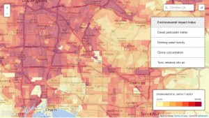
The Diesel particulate matter in the cities of Downey, Montebello, Norwalk, La Mirada, Commerce, Cerritos, Bellflower, Hawaiian Gardens and the City of Lakewood are approximately in the 80-100 percentile of being at risk with contaminants.
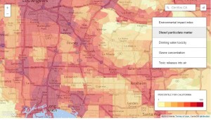
Drinking water toxicity in the areas of Cerritos, Artesia, La Palma, Hawaiian Gardens, parts of Bellflower, Downey, Bell Gardens, Commerce and Montebello are near the approximate 80-100 percentile of being at risk with contaminants.
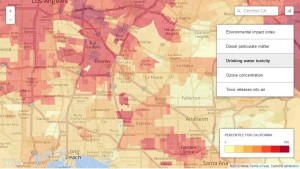
The Ozone concentration of Downey, Bell Gardens, Montebello, Cerritos, Artesia, Hawaiian Gardens, Norwalk, La Habra, La Palma, La Mirada Lakewood, Bellflower and Commerce are in the low percentile range of being at risk with contaminants.
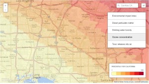
The cities of Downey, Bell Gardens, Montebello, Cerritos, Artesia, Hawaiian Gardens, Norwalk, La Habra, La Palma, La Mirada Lakewood, Bellflower and Commerce are all 100 percent at risk with toxic releases into the air.
Documents obtained by HMG-CN suggest projects could include energy-efficiency upgrades for homes in low-income areas, improvements to bus and rail systems, urban forestry projects and programs to fund cleaner trucks and equipment near ports, rail yards and distribution centers.
If you would like to review, the report based upon the research on the pollution levels please click on the following link.
Draft California Communities Environmental Health Screening Tool 2.0
4 Responses to Study Suggests ‘Dirty Air’ Clogging Southeast LA County Cities